Research

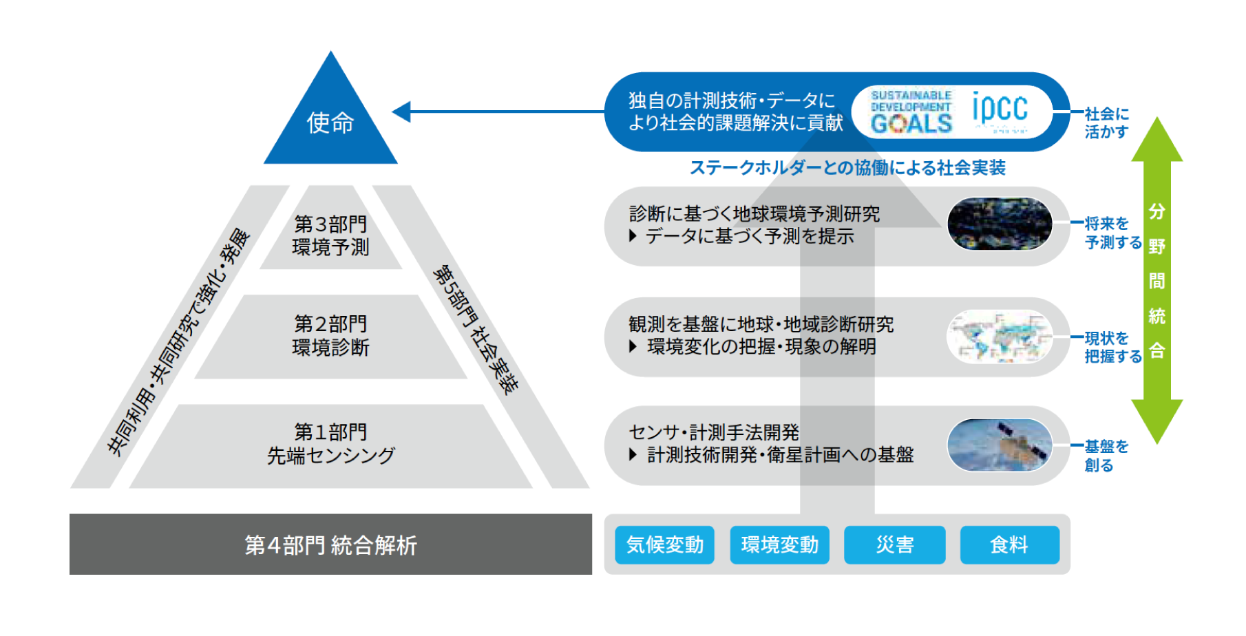
Center for Environmental Remote Sensing, CEReS, is contributing to the science community of environmental studies through archiving, evaluating, and disseminating satellite- and ground-based remote sensing data since its establishment as a national cooperative research center in 1995. Currently, the major research projects of CEReS are implemented in line with the following five research programs, namely, (Program 1) Innovation in Remote Sensing Technology and Algorithm, (Program 2) Environmental Diagnostics, (Program 3) Environmental Prediction, (Program 4) Integrative Analysis, Big Data Analysis, and (Program 5) Implementation of Remote Sensing in Society.

Innovation in Remote Sensing

Conducting advanced research on measurement technology, including sensor development, observation system development, and development of methods for extracting information from observation data.

【Professors】
・S・S Josaphat Tetuko
・IRIE Hitoshi
・HONDA Yoshiaki
・KAJIWARA Koji
・SAITOH Naoko
・YANG Wei

【keywords】
・Microwave sensors
・Microsatellite
・Large UAV
・UV-Visible spectroscopy
・Ground-based observation systems
・Algorithms for estimating physical quantity

Environmental Diagnostics

Conducting research to elucidate global environmental changes and their factors by utilizing satellite observations and ground observation databases.

【Professors】
・ICHII Kazuhito
・SAITOH Naoko
・YANG Wei
・IRIE Hitoshi
・HIGUCHI Atsushi

【keywords】
・Greenhouse gases
・Air pollutants
・Vegetation changes
・Terrestrial environmental changes
・Climate change/Human activities
・Interaction between atmosphere and land

Environmental Prediction

Conducting environmental forecasting research using numerical simulation and big data analysis based on various remote sensing data.

【Professors】
・KOTSUKI Shunji
・ICHII Kazuhito
・HATTORI Katsumi

【keywords】
・Data assimilation
・Artificial intelligence
・Disaster prediction
・Numerical modeling
・Weather forecast
・Climate change projection

Integration, Database

Contributing to a deeper understanding of the global environment through integrated analysis of global environmental information centered on remote sensing data.

【Professors】
・HIGUCHI Atsushi
・ICHII Kazuhito
・IRIE Hitoshi
・KOTSUKI Shunji
・SAITOH Naoko
・YANG Wei

【keywords】
・Database
・Bigdata analysis
・Artificial intelligence
・Geostationary meteorological satellite
・International ground-based remote sensing observation network
・Integrated analysis

Social Implementation

Implementing the results of remote sensing research into society and solving problems through collaboration with various stakeholders.

【Professors】
・KONDOH Akihiko
・HONGO Chiharu
・IRIE Hitoshi
・S・S Josaphat Tetuko
・KOTSUKI Shunji

【keywords】
・Food security
・Natural disaster and disaster prevention
・Contribution to policymaking
・Research and analysis of water environment
・Construction of sustainable social infrastructure
・Future earth observation satellite projects

Center for Environmental Remote Sensing Chiba University
タイトルとURLをコピーしました